

Latest Version
3.8.1
May 22, 2025
PixelProse SARL
Tools
Android
0
Free
net.androgames.compass
Report a Problem
More About Compass & Altimeter
The Ultimate Guide to Offline Compass Functionality and Geographic Navigation
In today's fast-paced world, having reliable navigation tools is essential, especially when venturing into remote areas without network access. This guide explores the remarkable features of offline compass applications, focusing on their functionality, accuracy, and various measurement capabilities.
Offline Functionality: Navigate Without Limits
One of the standout features of modern compass applications is their ability to function perfectly offline. This means you can rely on your compass even in areas with no cellular or Wi-Fi connectivity. Whether you're hiking in the mountains or exploring a remote forest, your compass will guide you without interruption.
Understanding Geographic North and Magnetic Declination
To navigate effectively, it's crucial to understand the difference between geographic north and magnetic north. Geographic north refers to the direction towards the North Pole, while magnetic declination is the angle between geographic north and magnetic north. Accurate navigation requires adjusting for this declination, ensuring you stay on course.
True Altitude Above Mean Sea Level (AMSL)
Knowing your true altitude above mean sea level (AMSL) is vital for various outdoor activities. Advanced compass applications utilize the EGM96 (Earth Gravitational Model) as a geoid reference to compute your altitude accurately. This feature is particularly useful for climbers and hikers who need to assess their elevation in relation to sea level.
Sunrise and Sunset Times: Plan Your Adventures
Understanding the timing of sunrise and sunset can significantly enhance your outdoor experience. Many compass applications provide accurate sunrise and sunset times based on your geographic location, allowing you to plan your activities accordingly and avoid getting caught in the dark.
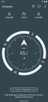
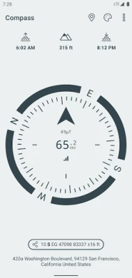
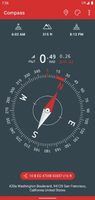
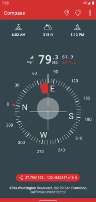
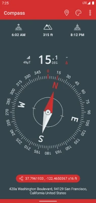
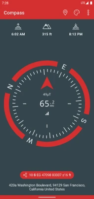
Azimuth Angles: Measure with Precision
Azimuth angles are essential for navigation, and modern compass applications offer measurements in various formats, including degrees, grads, milliradians (mrad), and gon. This versatility ensures that you can communicate your direction clearly, regardless of the measurement system you prefer.
Customizable Dials and Color Themes
Personalization is key in any application, and compass tools are no exception. Users can choose from various dials and color themes, including high-contrast options for better visibility in different lighting conditions. This customization enhances user experience and ensures that you can read your compass easily, even in challenging environments.
Angle Measurement Capabilities
Advanced compass applications come equipped with angle measurement functionalities. These tools allow users to measure angles accurately, making them invaluable for tasks such as surveying or setting up equipment. The inclusion of dials with measuring capabilities further enhances the utility of these applications.
Bubble Level Functionality: Ensure Accuracy
For those using iPhones, the bubble level functionality is a game-changer. This feature helps ensure that your device is level, which is crucial for accurate readings. Whether you're setting up a tent or aligning equipment, this functionality adds an extra layer of precision to your navigation tools.
Geographic Coordinate Formats: Latitude and Longitude
Modern compass applications support various geographic coordinate formats, including MGRS (Military Grid Reference System), UTM (Universal Transverse Mercator), and traditional latitude and longitude formats (DD, DMM, DMS). This flexibility allows users to work with the coordinate system that best suits their needs.
Coordinate Systems: British National Grid and SwissGrid
For users in the UK, the British National Grid (OSGB86) coordinate system is essential for accurate navigation. Similarly, SwissGrid (CH1903 / LV95 / MN95) is crucial for those navigating in Switzerland. These systems ensure that users can pinpoint their location with precision, enhancing their overall navigation experience.
Magnetic Field Strength: Detecting Perturbations
Understanding magnetic field strength is vital for accurate navigation. Advanced compass applications can detect potential magnetic perturbations that may affect your compass readings. This feature is particularly important in urban environments or areas with significant metal interference.
Sensor Accuracy: Trustworthy Navigation
Sensor accuracy is a critical factor in the reliability of any compass application. High-quality sensors ensure that your readings are precise, allowing you to navigate confidently. When choosing a compass app, consider the accuracy of its sensors to ensure you have the best possible navigation experience.
Current Location Address: Connectivity Requirements
While many features of compass applications work offline, obtaining the address of your current location typically requires data connectivity. This feature is useful for users who want to share their location or find nearby points of interest. However, it's essential to be aware of this requirement when planning your outdoor adventures.
Best Practices for Using Your Compass
To maximize the effectiveness of your compass, consider the following best practices:
- Use your compass in open areas where magnetic interference is minimal.
- Avoid magnetic closure cell phone cases that may disrupt compass accuracy.
- Regularly calibrate your compass to ensure accurate readings.
- Familiarize yourself with the features of your compass application to utilize its full potential.
Conclusion: Empower Your Navigation Skills
In conclusion, offline compass applications offer a wealth of features that enhance your navigation experience. From understanding geographic north and magnetic declination to measuring true altitude and azimuth angles, these tools are invaluable for outdoor enthusiasts. By leveraging the capabilities of modern compass applications, you can navigate confidently, even in the most remote locations.
Rate the App
User Reviews


Popular Apps


Editor's Choice