
Latest Version
2.4.5
October 14, 2025
AR Labs
Tools
Android
0
$2.49
com.arlabsmobile.altimeter
Report a Problem
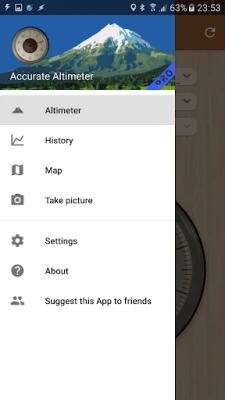
More About Accurate Altimeter PRO
Mastering Altitude Estimation: Reliable Methods for Accurate Measurements
When it comes to outdoor adventures, knowing your altitude can be crucial for safety and navigation. Whether you're hiking, climbing, or simply exploring, having reliable altitude measurements is essential. This article explores three effective methods for altitude estimation, ensuring you can always obtain accurate readings, even without an internet connection. Additionally, we will delve into historical charts, detailed maps, and impressive visuals that enhance your outdoor experience.
Three Reliable Methods for Altitude Estimation
Altitude can be estimated using various techniques, each with its own advantages. Here are three reliable methods to consider:
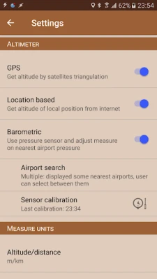
1. Satellite Triangulation
One of the most common methods for altitude estimation is satellite triangulation. This technique utilizes signals from multiple satellites to determine your position and altitude. While it may be slower and less accurate than other methods, it remains effective even without an internet connection. This makes it a valuable tool for adventurers in remote areas where connectivity is limited.
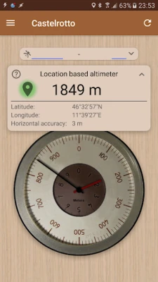
2. Ground Elevation from Global Maps
Another method involves referencing a global elevation map to determine the ground elevation at your current position. By inputting your coordinates, you can quickly obtain an altitude reading. This method is particularly useful for those who prefer a straightforward approach and need reliable data without the complexities of satellite triangulation.
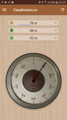
3. Pressure Sensor Utilization
If your device is equipped with a pressure sensor, you can leverage this feature for altitude estimation. The sensor calibrates itself based on atmospheric pressure readings from the nearest weather station, enhancing accuracy. This method is especially beneficial for those who frequently engage in outdoor activities, as it provides real-time altitude data that adjusts to changing weather conditions.
Enhancing Your Altitude Experience with PRO Features
For those seeking advanced capabilities, several PRO features can significantly enhance your altitude estimation experience:
Compensate Systematic Errors
One of the key advantages of upgrading to a PRO version is the ability to compensate for systematic errors in the pressure sensor. This feature ensures that your altitude readings are as accurate as possible, providing peace of mind during your excursions.
Download Larger Areas of Global Elevation Maps
With the PRO version, you can download extensive areas of global elevation maps. This feature is particularly useful for planning long hikes or climbs, allowing you to access detailed elevation data without relying on an internet connection.
Record Altitude Without Opening the App
Imagine being able to record your altitude seamlessly without the need to open the app. This feature allows for continuous tracking, ensuring you never miss a moment of your adventure. It’s perfect for those who want to focus on their experience rather than fiddling with their devices.
Unlimited Elevation Selection on Maps
Another significant advantage of the PRO version is the ability to pick elevation from any point on the map without limitations. This feature empowers you to explore various terrains and elevations, enhancing your navigation capabilities.
Ad-Free Experience
Lastly, upgrading to the PRO version provides an ad-free experience, allowing you to focus entirely on your outdoor activities without distractions. This streamlined experience enhances usability and ensures that you can access vital information quickly and efficiently.
Visualizing Your Altitude Journey
In addition to the methods and features mentioned, visual aids play a crucial role in understanding your altitude journey. Here are some ways to enhance your experience:
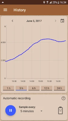
Historical Charts for Elevation Gain
Utilizing historical charts allows you to track your elevation gain over time. These charts provide valuable insights into your excursions, helping you analyze your performance and plan future adventures more effectively.
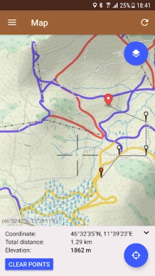
Detailed Maps with Peaks and Contour Lines
Accessing detailed maps that include peak names and contour lines is essential for any outdoor enthusiast. These maps not only help you navigate but also allow you to pick elevation from any point, ensuring you have a comprehensive understanding of the terrain.
Impressive Visuals of Places and Altitudes
Lastly, capturing pictures of impressive locations along with their altitude can enhance your outdoor experience. These visuals serve as a reminder of your adventures and can be shared with friends and family, inspiring them to explore the great outdoors.
Conclusion
In conclusion, mastering altitude estimation is vital for anyone who enjoys outdoor activities. By utilizing satellite triangulation, ground elevation maps, and pressure sensors, you can ensure accurate measurements regardless of your location. Additionally, the PRO features available can significantly enhance your experience, providing advanced capabilities that cater to your adventurous spirit. With the right tools and knowledge, you can confidently explore the great outdoors, knowing you have reliable altitude data at your fingertips.
Rate the App
User Reviews


Popular Apps


Editor's Choice