
Latest Version
4.62
June 09, 2025
Disciple Skies Software
Tools
Android
0
Free
com.discipleskies.android.altimeter
Report a Problem
More About Altimeter & Altitude Widget
Unlocking the Power of Elevation Data: Your Ultimate Guide to Accurate Altitude Measurement
Understanding elevation data is crucial for outdoor enthusiasts, adventurers, and professionals alike. Whether you're hiking, skiing, or conducting land surveys, having access to precise altitude information can enhance your experience and ensure safety. This article explores the best sources of elevation data and the innovative features of the DS Altimeter app, designed to provide you with accurate altitude measurements anytime, anywhere.
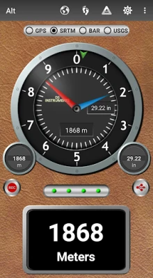
Top Sources of Elevation Data
When it comes to obtaining reliable elevation data, several sources stand out:
1. NASA's Shuttle Radar Topography Mission (SRTM)
The SRTM provides location-based altitude data, offering a comprehensive view of the Earth's topography. This data is invaluable for understanding the elevation of various terrains and is widely used in geographic studies.
2. Satellite-Based Altitude (GPS Altitude)
GPS technology allows for satellite-based altitude measurements, which are then corrected to reflect height above mean sea level (AMSL). This method is particularly useful for outdoor activities where precise elevation is necessary.
3. United States Geological Survey (USGS)
For those in the contiguous United States, southern Canada, and northern Mexico, the USGS provides actual land survey altitude values. This data is essential for professionals requiring accurate elevation information for mapping and surveying purposes.
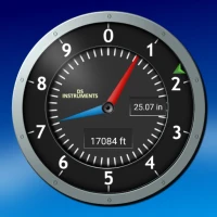
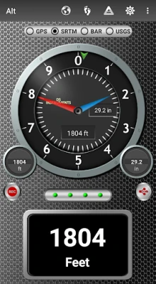
4. Barometric Altitude Measurement
Devices equipped with barometer sensors can measure pressure altitude, which is then converted to elevation above sea level. For the most accurate readings, it is recommended to calibrate the pressure altitude regularly.
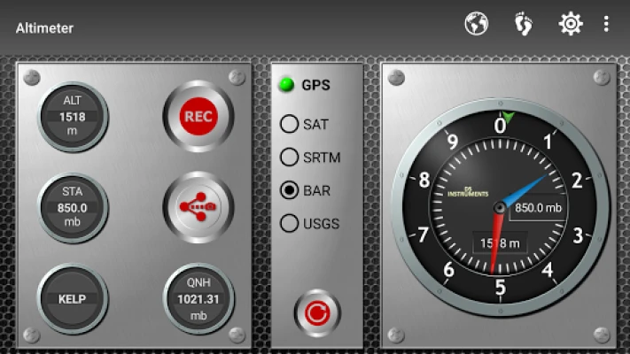
Calibrating Your Barometric Altimeter
The DS Altimeter app offers four effective calibration tools to ensure your readings are as precise as possible:
1. Airport Calibration
Calibrate your altimeter to the nearest airport by selecting it from the app's dynamic list. This data is updated every 20 to 30 minutes, ensuring accuracy.
2. QNH Value Input
Users can enter a QNH value to adjust their readings based on local atmospheric pressure, enhancing the accuracy of altitude measurements.
3. Benchmark Altitude Entry
Inputting a known altitude value for your specific location allows for precise calibration, ensuring that your readings reflect true elevation.
4. SRTM Altitude Map Calibration
Calibrate your barometric altimeter against the SRTM altitude map for an additional layer of accuracy, leveraging high-quality topographic data.
Offline Functionality of DS Altimeter
One of the standout features of the DS Altimeter app is its offline functionality. Both barometric altitude and GPS altitude corrected to elevation above sea level do not require an internet connection, making it ideal for remote locations.
Innovative Features of DS Altimeter
The DS Altimeter app is packed with features that enhance user experience and functionality:
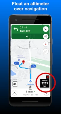
- Floating Altimeter: Place the altimeter over your navigation app or any other app for easy access to altitude data.
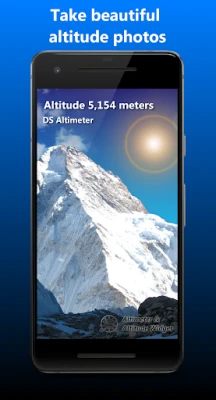
- Photo Altimeter: Capture images of your favorite high-altitude spots with the altitude displayed on the photograph.
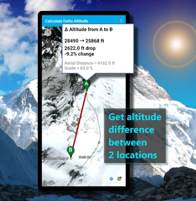
- Altitude Difference Measurement: Easily calculate the elevation difference and grade between two locations by tapping on a map.
- Altitude Profiles and Elevation Tracks: Record and analyze altitude profiles for your journeys, whether in the highlands or lowlands.
- Special Map Features: View your altitude recordings on included maps, with all track points displayed for easy reference.
- Elevation Search: Enter a place name or address to find the altitude above sea level at that specific location.
Upgrading to the pro version of the application unlocks even more features, including the Altimeter Widget for quick access to altitude data.
Perfect for Outdoor Activities
Whether you're skiing, hiking, or mountain climbing, the DS Altimeter app is the perfect companion. Record your ski runs and view elevation points on included maps, with minimum and maximum altitude clearly displayed. The app also features altitude mapping, allowing you to tap anywhere on a map to find the altitude and address of that location.
Permissions and Privacy Considerations
To ensure optimal functionality, the DS Altimeter app requires several permissions:
- Location Permission: Necessary for GPS functionality, allowing for accurate land survey altitude matching.
- Photos/Media/Files Permission: Required for screen capture, enabling users to share altitude results.
- Boot and Wake-up Permissions: Needed to refresh values on the Altimeter Widget and reactivate it after phone restarts.
- Internet and Network Permissions: Essential for accessing online land survey databases.
- Billing Permission: Required for purchasing the application and activating premium features.
- Vibrate Permission: To alert users of important notifications.
Conclusion
In conclusion, having access to accurate elevation data is essential for anyone involved in outdoor activities or land surveying. The DS Altimeter app stands out with its innovative features, offline functionality, and reliable calibration tools. Whether you're exploring the great outdoors or conducting professional surveys, this app is your go-to solution for precise altitude measurements. Embrace the adventure and elevate your experience with the DS Altimeter!
Rate the App
User Reviews


Popular Apps


Editor's Choice