
Latest Version
1.5.13
April 28, 2026
4Digsoft
Tools
Android
0
Free
glandgo.gpsarea.fieldareameasure
Report a Problem
More About GPS Field Measure - GLandGo
Unlock Precision with GLandGo: The Ultimate GPS Area Measurement App
In the realm of land surveying, accuracy and efficiency are paramount. Enter GLandGo, the cutting-edge GPS Area Measurement app that empowers users to conduct precise land measurements directly from their mobile devices. Whether you’re a farmer, land surveyor, or outdoor enthusiast, GLandGo is designed to meet your needs with unparalleled reliability and professionalism.
Pro-Grade GPS Integration for Enhanced Accuracy
GLandGo now supports external Bluetooth GPS devices, allowing users to bypass the limitations of standard smartphones. This integration ensures high-precision surveying, making it an essential tool for professionals who demand accuracy in their measurements.
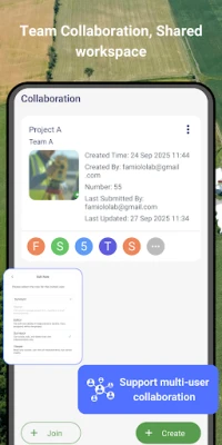
Major Update: Collaboration Mode for Seamless Teamwork
One of the standout features of GLandGo is its Collaboration Mode. This update allows users to create projects, add multiple accounts, and collaborate effectively with their teams. All measurement records are synced in real-time, and different project roles come with tailored permissions, ensuring smooth and efficient teamwork.
Key Features of GLandGo
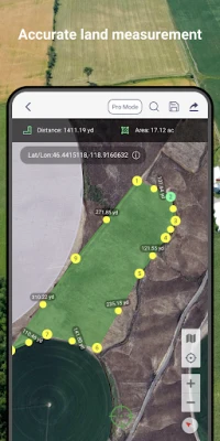
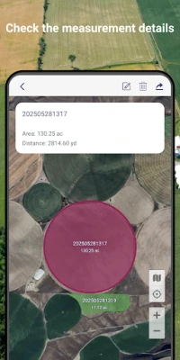
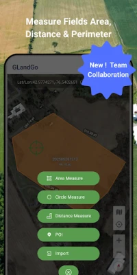
1. GPS Area Measurement
- Measure land by walking the perimeter or placing points manually on the map.
- Save results with names, notes, photos, and categories.
- Supports multiple units: hectares, acres, square meters, and more.
2. Distance Measurement
- Track path lengths and calculate straight-line or multi-point distances.
- Supports both GPS tracking and manual distance input.
3. Manual Coordinate Input
- NEW: Precisely add points by entering latitude and longitude.
- Ideal for remote mapping and GPS data referencing.
4. Location Marking & Organization
- Save and categorize important locations for future reference.
5. GPS Tools & Navigation
- Built-in compass for field alignment.
- Real-time GPS tracking, direction, and satellite positioning.
6. Import & Export Support
- Import formats: SHP, GeoJSON, KML, KMZ.
- Export formats: SHP, KML, JPG, PDF, GeoJSON, CSV.
- Share measurement results via custom web links.
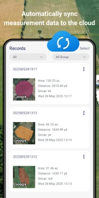
7. GLandGo Cloud for Data Security
Protect your valuable data with built-in cloud and local backup options, ensuring your information is safe and accessible.
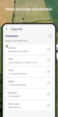
8. Professional Mapping Support
- Coordinate formats: DMS, UTM, MGRS, Plus Code, Geohash.
- Map history tracking for easy reference.
- Customizable map types and themes to suit your preferences.
9. Collaboration Features
Add multiple users to projects, assign roles, and collaborate with real-time data synchronization for enhanced productivity.
10. Cross-Platform Sync
Log in with your account to seamlessly access your data across both Android and iOS devices. Whether you switch phones or use multiple platforms, your data remains synchronized in the cloud.
11. Circle Area Measurement
Quickly measure circular plots of land by setting the center and radius, making it easier to assess various land shapes.
12. Manual Coordinate Entry
Add precise location points by entering coordinates manually, enhancing your mapping capabilities.
13. Added Support for WMS Map Layers
GLandGo now supports WMS map layers, providing users with even more mapping options.
New Feature: Image Layers for Enhanced Field Mapping
Experience smarter field mapping with the new Image Layer feature. Import and overlay images directly on the map, allowing for easy comparison of drone photos, survey maps, or satellite images. This update enhances both area measurement and distance measurement, making it easier to manage land, farms, or projects with clarity and precision.
Who Can Benefit from GLandGo?
GLandGo is perfect for a variety of professionals and enthusiasts, including:
- Farmers & Agronomists
- Land Surveyors
- Real Estate Professionals
- Engineers & Architects
- Environmental Planners
- Outdoor Enthusiasts & Hikers
- GIS Surveyors
Download GLandGo Today!
Transform the way you measure land and distances with GLandGo, your go-to GPS Fields Area Measure Map, Map Area Calculator, Field Area Measure, and GPS Land Measurement & Survey solution. Download GLandGo – GPS Area Measurement today and discover the easiest and most powerful way to measure land and distances anywhere.
Rate the App
User Reviews


Popular Apps


Editor's Choice