


Latest Version
4.5.1
July 29, 2025
PixelProse SARL
Tools
Android
0
Free
fr.avianey.altimeter
Report a Problem
More About Altimeter
Unlocking True Altitude: The Ultimate Guide to Accurate Elevation Measurement
Understanding altitude is crucial for various applications, from aviation to outdoor adventures. This article delves into the intricacies of measuring true altitude above sea level, emphasizing the importance of accuracy and the tools available for precise elevation readings.
What is True Altitude Above Sea Level?
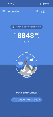
True altitude, or height above mean sea level (AMSL), refers to the elevation of an object relative to the average sea level datum. This measurement is essential for various fields, including aviation, meteorology, and geography. Unlike standard GPS elevation, which treats the Earth as an ellipsoid, true altitude utilizes a geoid-based vertical datum, such as the EGM96 model, to provide more accurate readings.
Offline Functionality: No Network Required
One of the standout features of modern altitude measurement applications is their ability to function offline. Users can access true altitude data without needing a network connection, making it ideal for remote locations or during flights. This offline capability ensures that adventurers and professionals can rely on accurate altitude readings regardless of their connectivity status.
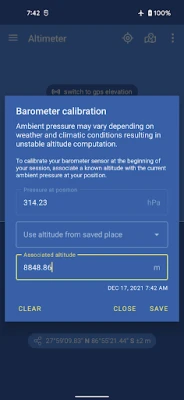
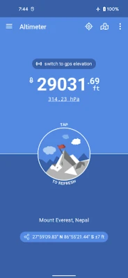
Utilizing Barometer and GPS for Accurate Measurements
Altitude can be determined using two primary methods: barometric pressure and GPS satellites. The barometric method measures changes in atmospheric pressure to calculate elevation, while GPS relies on satellite signals to determine position and altitude. Combining these two methods can enhance accuracy, providing users with reliable altitude readings.
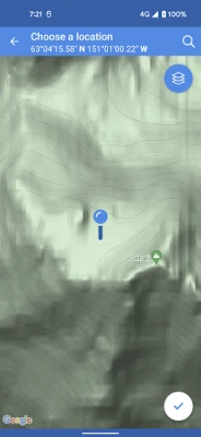
Address and Location Features
Modern altitude measurement tools allow users to easily find their current location and obtain the corresponding altitude. Users can:
- Save altitude data at specific locations for future reference.
- Search for locations by name or address, streamlining the process of finding altitude information.
- Pick locations directly on a map, making it intuitive to explore different areas.
Understanding Altitude Accuracy Estimation
Altitude accuracy is a critical factor in ensuring reliable measurements. It is defined at a 68% confidence level, meaning there is a 68% probability that the true altitude lies within a specified range above and below the reported value. This estimation is vital for users who require precise altitude data for their activities.
Horizontal Accuracy and Its Importance
In addition to vertical accuracy, horizontal accuracy is equally important. This measurement indicates how precisely a location is identified on a map. High horizontal accuracy ensures that users can trust the altitude readings associated with their chosen locations, enhancing the overall reliability of the data.
Geotagging Photos with Altitude Information
Another innovative feature of altitude measurement applications is the ability to open photo geotags. This functionality allows users to view the altitude associated with specific images, providing context and enhancing the storytelling aspect of photography. Whether documenting a hike or a scenic view, knowing the altitude can add depth to the experience.
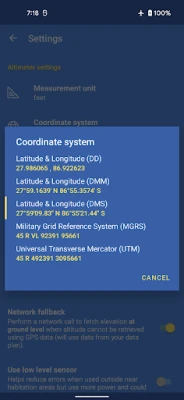
Universal Transverse Mercator (UTM) and Military Grid Reference System (MGRS)
For those in need of precise location data, the application supports Universal Transverse Mercator (UTM) coordinates and Military Grid Reference System (MGRS) coordinates. These systems provide a standardized way to identify locations on the Earth's surface, making it easier for users to communicate and share altitude information accurately.
Home Screen Widget for Quick Access
To enhance user experience, many altitude measurement applications offer a home screen widget that displays the current altitude. This feature allows users to quickly check their elevation without navigating through the app, making it convenient for outdoor enthusiasts and professionals alike.
Conclusion: Elevate Your Experience with Accurate Altitude Measurement
Accurate altitude measurement is essential for various applications, from outdoor adventures to professional use. By leveraging offline capabilities, barometric and GPS methods, and advanced features like geotagging and coordinate systems, users can ensure they have the most reliable altitude data at their fingertips. Embrace the power of technology to enhance your understanding of elevation and make informed decisions based on accurate altitude readings.
Rate the App
User Reviews


Popular Apps


Editor's Choice