
Latest Version
2024.9.14
September 17, 2024
Watch Duty
Communication
Android
0
Free
org.watchduty.app
Report a Problem
More About Watch Duty (Wildfire)
Comprehensive Wildfire Tracking: Stay Informed and Safe
In an era where wildfires pose significant threats to communities and ecosystems, having access to reliable wildfire tracking features is essential. This article delves into the key functionalities that can help you stay informed about nearby wildfires and firefighting efforts, ensuring your safety and preparedness.
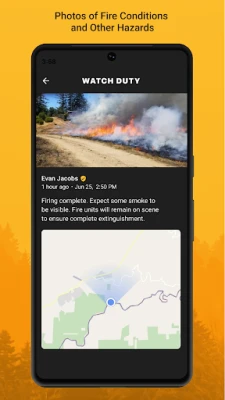
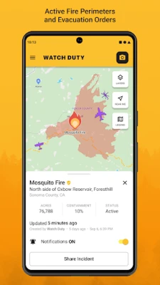
Real-Time Wildfire Notifications
One of the standout features of modern wildfire tracking systems is the ability to receive push notifications about nearby wildfires. These alerts keep you updated on the latest firefighting efforts and any changes in wildfire conditions. By staying informed, you can make timely decisions to protect yourself and your loved ones.
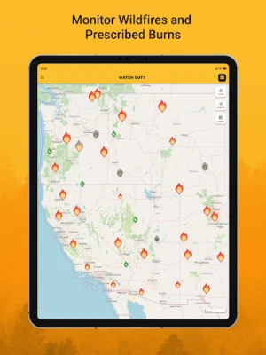
Live Updates on Wildfire Conditions
Wildfire conditions can change rapidly. With real-time updates, you can monitor the active fire perimeters and track the progress of ongoing firefighting operations. This feature is crucial for understanding the immediate risks in your area and for planning your next steps effectively.
Advanced Satellite Monitoring
Utilizing advanced technology, wildfire tracking services provide infrared satellite hotspots from sources like VIIRS and MODIS. These satellite images allow you to visualize the extent of wildfires and identify hotspots that may not be visible to the naked eye. This information is invaluable for assessing the situation and determining the best course of action.
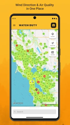
Wind Speed and Direction Insights
Understanding wind speed and direction is critical during wildfire events. Wind can significantly influence the spread of fires, making it essential to have access to this data. By monitoring wind patterns, you can better anticipate how a wildfire may behave and prepare accordingly.
Evacuation Orders and Shelter Information
In the event of a wildfire, knowing when to evacuate is vital. Wildfire tracking services provide timely evacuation orders and information about nearby shelters. This feature ensures that you have the necessary information to evacuate safely and find refuge when needed.
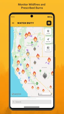
Historical Wildfire Data
Access to historical wildfire perimeters can provide valuable insights into fire patterns and behaviors in your area. By analyzing past wildfires, you can better understand potential risks and prepare for future incidents. This data can also assist in community planning and resource allocation.
Interactive Maps for Enhanced Navigation
Wildfire tracking services often include street and satellite maps that allow you to navigate your surroundings effectively. These maps can help you identify safe routes for evacuation and locate resources such as shelters and emergency services. Having a clear understanding of your environment is crucial during a wildfire crisis.
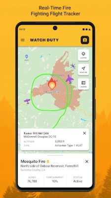
Air Attack and Tanker Flight Tracking
Monitoring air attack and air tanker flights provides insight into firefighting efforts from above. Knowing where aerial resources are deployed can help you understand the scale of the firefighting response and the effectiveness of these efforts in combating the wildfire.
Save Your Locations for Quick Access
Another useful feature is the ability to save locations for quick access on the map. Whether it’s your home, a family member’s residence, or a nearby shelter, having these locations readily available can streamline your decision-making process during emergencies.
Support Our Mission
Watch Duty is a 501(c)(3) non-profit organization dedicated to providing these essential wildfire tracking services free of charge and without advertising. You can support our mission with a $25/year membership, which grants access to special features as a token of our appreciation. Your support helps us continue to provide vital information to those in need.
Disclaimer and Information Sources
It’s important to note that Watch Duty is not affiliated with any government agency. The information provided through our app is sourced from publicly available and trusted resources, including:
- National Oceanic and Atmospheric Administration (VIIRS, MODIS)
- National Interagency Fire Center (NIFC)
- California Department of Forestry and Fire Protection (CAL FIRE)
- California Governor's Office of Emergency Services (Cal OES)
Contact Us for Support
If you have any questions or need support, feel free to reach out to us at support@watchduty.org.
Privacy Policy
For more information on how we handle your data, please review our Privacy Policy.
Stay informed, stay safe, and let us help you navigate the challenges posed by wildfires with our comprehensive tracking features.
Rate the App
User Reviews


Popular Apps


Editor's Choice