


Latest Version
8.1.1
January 25, 2026
3Planesoft
Education
Android
0
$2.99
com.a3planesoft.earth101
Report a Problem
More About Earth 3D - World Atlas
Explore the World: Unveiling the Ultimate Geographic Experience
In an age where knowledge is at our fingertips, understanding our planet has never been more accessible. This article delves into an extraordinary geographic tool that offers a comprehensive view of Earth, combining stunning visuals with rich information. Whether you're a student, a traveler, or simply a geography enthusiast, this resource is designed to enhance your understanding of the world around you.
Relief Model of the Earth
Experience the Earth like never before with a detailed relief model that showcases the planet's topography. This feature allows users to visualize mountains, valleys, and plains in a three-dimensional format, providing a realistic representation of our diverse landscapes. The relief model serves as an essential tool for educators and learners alike, making geography engaging and interactive.
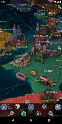
Comprehensive Political and Physical Maps
Navigate the globe with ease using world political and physical maps. These maps offer a clear depiction of countries, borders, and geographical features, allowing users to understand the political landscape and natural formations of our planet. With high-resolution imagery, users can zoom in on specific regions, making it perfect for research or travel planning.
Dynamic Day/Night Cycle with City Lights
Witness the beauty of our planet's day and night cycle, complete with illuminated cityscapes. This feature not only enhances the visual experience but also provides insight into human activity across different time zones. Users can observe how cities come alive at night, showcasing the vibrancy of urban life around the globe.
Understanding Time Zones
Time zones can be complex, but this tool simplifies the concept. Users can easily identify different time zones across the world, making it easier to plan international communications or travel. This feature is particularly beneficial for businesses and individuals who operate across multiple regions.
Explore Over 2,600 Geographic Objects
Dive into a vast database of more than 2,600 geographic objects. From mountains and rivers to cities and landmarks, this extensive collection provides a wealth of information. Each object is meticulously detailed, offering insights into its significance and characteristics, making it an invaluable resource for students and researchers.
Discover the Wonders of the World
With over 500 wonders of the world included, users can embark on a virtual journey to some of the most breathtaking sites on Earth. This feature highlights both natural and man-made wonders, allowing users to appreciate the beauty and diversity of our planet. Each wonder comes with a full description, enriching the learning experience.
Vast Collection of Over 2,100 Photos
Visual learners will appreciate the extensive library of more than 2,100 high-quality photos. These images capture the essence of various geographic locations, providing a visual context that complements the textual information. Users can explore different cultures, landscapes, and environments through stunning photography.
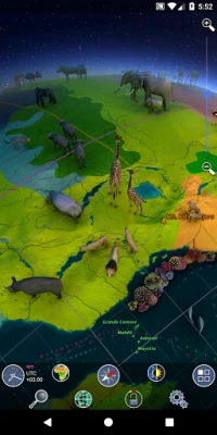
Human, Animal, and Plant World Add-Ons
Enhance your geographic exploration with specialized add-ons focusing on the Human World, Animal World, and Plant World. These features provide in-depth information about human societies, wildlife, and plant life, allowing users to gain a holistic understanding of the interconnectedness of life on Earth.
Sky Map Add-On
Expand your exploration beyond the Earth’s surface with the Sky Map add-on. This feature allows users to identify stars, constellations, and celestial events, bridging the gap between geography and astronomy. It’s an excellent tool for stargazers and those interested in the cosmos.
Detailed Descriptions of Geographic Points
Every geographic object or point on the surface comes with a full description, providing users with essential information at their fingertips. This feature ensures that learners can access detailed insights, enhancing their understanding of each location's historical, cultural, and environmental significance.
Advanced Zoom Capabilities
With a remarkable 15x zoom feature, users can explore the minutiae of any location. This capability allows for an in-depth examination of geographic features, making it easier to study specific areas or plan trips with precision. The zoom function enhances the overall user experience, making exploration both detailed and enjoyable.
Real-Time Global Weather Updates
Stay informed with real-time global weather updates. This feature provides users with current weather conditions across the globe, making it an essential tool for travelers and those interested in climate patterns. Understanding weather trends can significantly enhance travel planning and outdoor activities.
Engaging Demo Mode with Original Music
Experience the platform's capabilities through an engaging demo mode, complete with an original music track. This feature allows users to explore the tool's functionalities in a captivating way, making it an enjoyable introduction for new users. The combination of visuals and music creates an immersive experience that draws users in.
Continuous Updates and Expanding Data
As our world evolves, so does this geographic tool. New data is constantly being added, ensuring that users have access to the latest information and features. This commitment to continuous improvement means that users can expect regular updates, enhancing their experience and knowledge over time.
In conclusion, this geographic tool is a treasure trove of information and visual experiences, making it an essential resource for anyone interested in exploring our planet. With its diverse features, users can engage with the world in a way that is both educational and entertaining. Whether for personal enrichment or academic purposes, this tool is poised to transform how we understand geography.
Rate the App
User Reviews


Popular Apps


Editor's Choice