Latest Version
1.0.7
May 20, 2026
akira miyagawa
Games
Android
0
Free
com.kudougames.worldmapstudy
Report a Problem
More About World Map Puzzle Quiz Flag
Explore Engaging Playable Modes for Learning Geography
In the digital age, learning geography has never been more interactive and enjoyable. With a variety of playable modes designed to enhance your knowledge, you can dive into the fascinating world of countries, capitals, and flags. This article explores the different modes available, along with useful features that make your learning experience even more enriching.
Diverse Playable Modes
Engagement is key when it comes to learning, and the following modes offer unique ways to test and expand your geographical knowledge:
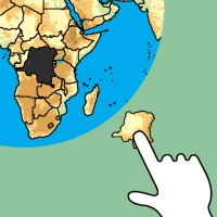
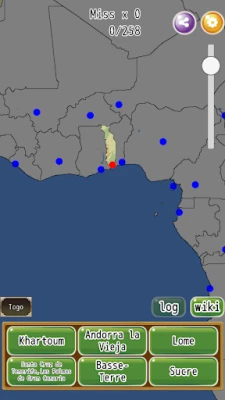
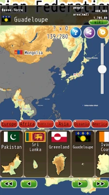
Puzzle Mode
Challenge yourself with the puzzle mode, where you can piece together the geographical landscape of various countries. This interactive format not only helps you learn about the locations of countries but also enhances your spatial awareness and problem-solving skills.
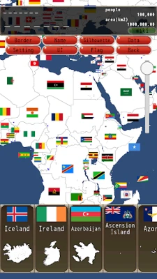
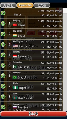
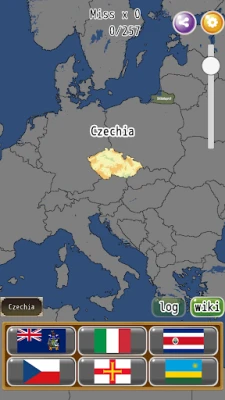
Country Name and Capital Quiz
Test your knowledge with the country name and capital quiz. This mode allows you to match countries with their respective capitals, reinforcing your memory and understanding of global geography. It's a fun way to prepare for quizzes or simply to impress your friends with your geographical prowess!
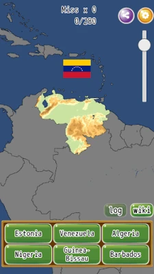
Flag Quiz
Put your knowledge of national symbols to the test with the flag quiz. Identify flags from around the world and learn about the countries they represent. This mode is perfect for visual learners and those who enjoy a challenge.
Various Useful Functions to Enhance Learning
In addition to the engaging playable modes, several useful functions can enhance your learning experience:
Browsing Functionality
The browsing feature allows you to explore additional resources and information about countries, capitals, and flags. This function is invaluable for those who want to delve deeper into geographical topics and expand their knowledge beyond the quizzes.
Text-To-Speech Feature
For auditory learners, the text-to-speech function provides an excellent way to absorb information. Listen to the names of countries and capitals pronounced correctly, helping you improve your pronunciation and retention of geographical terms.
Landscape and Portrait Mode Switching
Flexibility is essential in learning, and the ability to switch between landscape and portrait modes ensures that you can study in a way that suits your preferences. Whether you’re on a mobile device or a tablet, this feature enhances usability and comfort.
Customizable Difficulty Levels
To cater to learners of all levels, the platform allows you to adjust the difficulty level by changing various settings. This customization ensures that you can challenge yourself appropriately and track your progress effectively.
Show/Hide Boundary Lines
One way to increase the challenge is by choosing to show or hide boundary lines. This feature encourages you to rely on your knowledge rather than visual cues, making it a great way to test your understanding of geographical borders.
Show/Hide Names
Another option is to show or hide names of countries and capitals. By hiding names, you can push yourself to recall information from memory, which is an excellent way to reinforce learning.
Switch Between Elevation Map and Silhouette
Lastly, the ability to switch between an elevation map and a silhouette (white map) provides a unique perspective on geographical features. The elevation map offers insights into the topography of regions, while the silhouette mode challenges you to identify countries based solely on their shapes.
Conclusion
With a variety of playable modes and useful functions, learning geography has become an engaging and interactive experience. Whether you’re a student, a teacher, or simply a geography enthusiast, these tools provide an excellent way to enhance your knowledge and skills. Dive into the world of geography today and discover how fun and rewarding learning can be!
Rate the App
User Reviews


Popular Apps


Editor's Choice